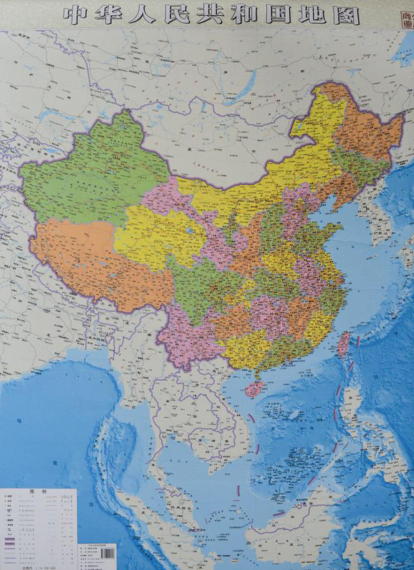
China publishes new map

China’s latest published map shows its claim over the South China Sea by marking ten dash lines around the region just off the coasts of Vietnam, Malaysia, Brunei, and the Philippines’ islands of Palawan and Luzon. PHOTO sourced from China Daily/ANN
MANILA, Philippines—China has published a new map of the entire country including the islands in the South China Sea (West Philippine Sea) in order to “better show” its territorial claim over the region.
The government-run Xinhua news agency of China published photos of the map made by Hunan Map Publishing House and said in the caption “Islands in South China Sea share the same scale with mainland and are better shown than traditional maps.”
The map shows China’s claim over the South China Sea by marking ten dash lines around the region just off the coasts of Vietnam, Malaysia, Brunei, and the Philippines’ islands of Palawan and Luzon.
China’s claim over the region, believed to be rich in oil and natural gas and a vital shipping route, has been challenged by the Philippines before the International Tribunal on the Law of the Sea (Itlos).
Several reclamation activities on reefs in the Spratly Islands are being conducted by China as shown by a series of aerial photographs of Mabini reef (Johnson South Reef) released by the Department of Foreign Affairs (DFA).
Article continues after this advertisementThe reclamation is regarded as China’s way of furthering its “expansionist agenda” in the region, DFA secretary Albert del Rosario said in previous media interviews.
Article continues after this advertisementSupreme Court Associate Justice Antonio Carpio debunked China’s historical claims in public lectures saying that “There is not a single ancient map, whether made by Chinese or foreigners, showing that the Spratlys and Scarborough Shoal were ever part of Chinese territory.”
“China’s so-called historical facts to justify its nine-dash line are glaringly inconsistent with actual historical facts, based on China’s own historical maps, constitutions and official pronouncements,” Carpio said.
China remains in control of large parts of the South China Sea and Chinese maritime security vessels have repeatedly used water cannons to drive away Filipino fishermen from Scarborough Shoal and from areas in the Spratly Islands.
RELATED STORIES
China turning reefs into ‘artificial islands’ for ‘dominance’–expert