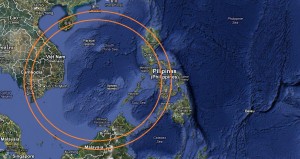
On September 5, the President signed Administrative Order No. 29, “Naming the West Philippine Sea of the Republic of the Philippines, and for other purposes.”
“These areas include the Luzon Sea as well as the waters around, within and adjacent to the Kalayaan Island Group and Bajo de Masinloc, also known as Scarborough Shoal,” Mr. Aquino says in the order made public only Wednesday.
In interview at Camp Crame, Mr. Aquino said he was still looking forward to a meeting with Chinese President Hu Jintao, whom he missed seeing at the 20th Asia Pacific Economic Cooperation (Apec) leaders’ summit in Vladivostok, Russia, on Sunday.
“I am still hoping that we can have a dialogue where we can have a heart-to-heart talk and [real] sharing of all of our thoughts in total honesty and openness. So that seems to be the way forward to settle all of these things,” Mr. Aquino said, referring to the Philippines’ territorial dispute with China in the West Philippine Sea.
Portions of South China Sea
The Aquino administration began calling the South China Sea West Philippine Sea in March last year after Chinese patrol ships harassed a Philippine scientific vessel and fired across the bows of Philippine fishing boats in waters within the country’s claim in the Spratly chain.
In Wednesday’s interview Mr. Aquino clarified that AO 29 covered only “portions of the South China Sea.”
Those waters encompass the Philippines’ 370-kilometer EEZ, Mr. Aquino said.
Scarborough Shoal, also known as Panatag Shoal, is within the country’s EEZ, he said.
“I just want to be precise … I’m sure that Panatag Shoal or Bajo de Masinloc is within our EEZ and also they have been [part of the country] historical[ly],” Mr. Aquino said.
Different names
“Does it help our cause? It is important to clarify which portions we claim as ours versus the entirety of the South China Sea,” Mr. Aquino said, explaining to reporters the need to officially rename the area because some countries call it by other names.
“We call it West Philippine Sea. There is a portion of it they call East Sea. Each one calls it by another name. Let’s make clear what areas we claim as ours,” he said.
To justify the official renaming of waters to the west of Palawan and Zambales provinces, the order points out that Presidential Decree No. 1599 (issued in 1978) established the Philippine EEZ.
In 2009, Congress enacted Republic Act No. 9522, the Baselines Law, which defined and described the baselines of the Philippine archipelago.
Sovereign rights
According to the AO 29, the Philippines exercises “sovereign rights under the principles of international law, including the 1982 United Nations Convention on the Law of the Sea (Unclos), to explore and exploit, conserve and manage the natural resources, whether living or nonliving, both renewable and nonrenewable, of the seabed, including the subsoil and the adjacent waters, and to conduct other activities for the economic exploitation and exploration of its maritime domain, such as the production of energy from the water, currents and winds.”
It says the Philippines exercises “sovereign jurisdiction” over its EEZ with regard to the establishment and use of artificial islands, installations and structures; marine scientific research; protection and preservation of the marine environment; and other rights and duties provided for in Unclos.
The order explains that in the exercise of sovereign jurisdiction, “the Philippines has the inherent power and right to designate its maritime areas with appropriate nomenclature for purposes of the national mapping system.”
The shift to West Philippine Sea, the order says, is without prejudice to the determination of the maritime domain of territories over which the Philippines has sovereignty and jurisdiction.
Make it international
The order directs the National Mapping and Resource Information Authority (Namria) to produce and publish charts and maps of the Philippines showing the West Philippine Sea.
It says the Department of Foreign Affairs (DFA), in consultation with Namria and other appropriate governmental agencies, will deposit, at the appropriate time, a copy of the order enclosing the official map showing the West Philippine Sea with the Secretary General of the United Nations and notify accordingly relevant international organizations, such as the International Hydrographic Organization and the United Nations Conference on the Standardization of Geographical Names.
The order directs all governmental agencies to use the name West Philippine Sea in all communications, messages and public documents, to popularize the use of the name, both domestically and internationally.
They are also directed to use the official Philippine maps produced and published by Namria showing the West Philippine Sea.

