Fujiwhara: Like 2 storms dancing
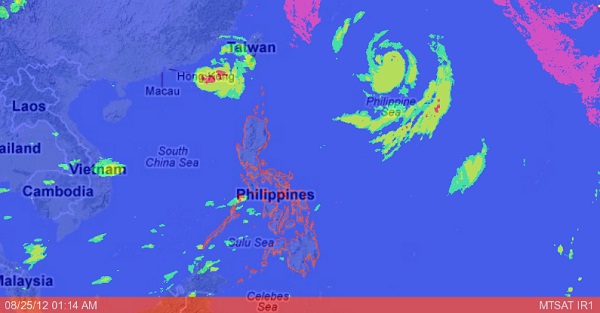
MANILA, Philippines—Typhoons “Igme” and “Julian” appear destined to meet in a Fujiwhara dance across Philippine skies.
Even after making landfall in Taiwan, the weakening Igme looks to be heading back to the Philippines, while the stronger Julian is steadily approaching the country, the state weather bureau said on Friday.
The interaction between the two storms indicates what could be the start of the “Fujiwhara Effect,” the Philippine Atmospheric, Geophysical and Astronomical Services Administration (Pagasa) said.
The phenomenon is described by the US National Weather Service as the tendency of two storms to move around a common pivot. It will appear like two storms are dancing or orbiting around each other, one moving in a counter-clockwise direction.
“Typhoon Igme is forecast to make a counter-clockwise looping motion within the next 24-48 hours due to its interaction with Typhoon Julian,” Pagasa said.
Making a U-turn
“It’s making a U-turn,” Pagasa forecaster Aldczar Aurelio said of Igme. But it does not appear likely that Igme and Julian will merge because both are relatively strong typhoons, he added.
“They will only merge if one of them becomes weaker and turns into a tropical storm, a tropical depression or a low pressure area,” he told the Inquirer.
The likely scenario so far, Aurelio said, was that Igme would return to the country, while Julian would move toward Japan. He predicted that Igme would leave the country on Monday or Tuesday, while Julian would probably exit at least a day earlier, on Sunday afternoon.
As of Friday, Storm Signal No. 2 (61-100 kph winds) was still up over the Batanes group of islands, while Signal No. 1 (30-60 kph winds) was raised in the Calayan and Babuyan groups of islands.
As of 4 p.m. on Friday, Igme was observed at 260 kilometers north-northwest of Basco, Batanes, while Julian was seen 1,000 km east of the same town.
Igme slightly weakened after interacting with the rugged terrain of southern Taiwan, packing maximum sustained winds of 120 kph near the center and gusting up to 150 kph, Pagasa said.
Typhoon parted
An indication that the Fujiwhara Effect was already starting was that Igme was moving west-southwest at a slow 7 kph, Aurelio said.
On the other hand, Julian maintained its strength as it moved in a northwest direction at a faster pace of 15 kph, with maximum sustained winds of 150 kph near the center.
The last time the Fujiwhara Effect was observed in the Philippines was when approaching Typhoon Quedan “pulled back” the exiting Typhoon Pepeng in October 2009, causing it to linger within the country’s territory for days.
Aurelio recalled that the two typhoons did not end up merging but parted ways eventually.
Igme and Julian are expected to enhance the southwest monsoon that will bring rains over the northern and western sections of the country, Pagasa said.
But rainfall amount will be insignificant due to weak southwest monsoon, according to Pagasa Administrator Nathaniel Servando.
Cloudy over Manila
Over the weekend, Metro Manila will be generally cloudy with light rain showers, the weather bureau predicted.
“This weather condition will continue to prevail in the next three days (Friday-Sunday) as Typhoons Igme and Julian interact with each other before leaving the country by Tuesday and Monday, respectively,” it said.
The eye of Igme is expected to be 380 km west-northwest of Basco by Saturday afternoon, Pagasa said.
On the other hand, Julian is forecast to be 820 km east-northeast of Basco by Saturday morning, 640 km northeast of that town by Sunday morning, and 740 km north-northeast by Monday morning, it added.
Stormy in Batanes
Batanes will experience stormy weather while the Calayan and Babuyan islands will have rains with gusty winds, Pagasa said in a 5 p.m. advisory. Coastal waters along these areas will be rough to very rough.
The rest of the country will have mostly cloudy skies with scattered rain showers and thunderstorms, and moderate to strong winds blowing from the southwest will prevail over the rest of Luzon and Visayas.
Fishing boats and other small seacraft are advised not to venture out into the northern and eastern seaboards of Luzon due to big waves generated by Igme and Julian, Pagasa said.
