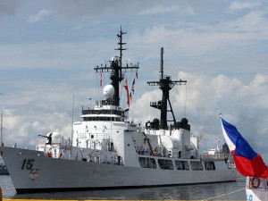
IMPASSE AT HIGH SEAS The BRP Gregorio Del Pilar, the country’s biggest warship, figures in a tense standoff with Chinese surveillance ships at the Scarborough Shoal. EDWIN BACASMAS
The Scarborough Shoal (Philippine name: Panatag Shoal; Chinese name: Huangyan Dao) is a triangle-shaped chain of reefs and islands surrounding a lagoon covering an area of 150 square kilometers.
The closest Philippine land mass is Palauig in Zambales province, 220 km away. It is also 350 km from Manila and more than 800 km southeast of Hong Kong.
Several islands in Scarborough are 3 meters high, while many of the reefs are below water at high tide. Several rocks also dot Scarborough, the most prominent of which is South Rock, 1.8 meters above water at high tide.
Not part of Spratlys
Abundant marine resources in the area attract fishermen from both China and the Philippines, which both claim it as part of their territory.
It is however not part of the Spratly Islands where China, the Philippines and four other Asian nations are embroiled in a separate territorial quarrel.
In 1965, the Philippine Navy constructed an iron tower near the mouth of Scarborough’s lagoon.
In 1995, China and the Philippines signed a code of conduct pledging to solve their dispute by peaceful means.
Hundreds of ships pass through the vicinity of Scarborough. A 1999 bulletin by the University of Durham International Boundaries Research Unit said Japan used the route to transport 80 percent of its petroleum from the Middle East.
On June 6, 2011, following news of tension between China and the Philippines over territorial claims, the provincial board of Zambales endorsed the claim of Masinloc town over the Scarborough Shoal to “strengthen the claim of the Philippines on that area.” Inquirer Research
Sources: National Mapping and Resource Information Authority; Scarborough Evening News; Ibru Boundary and Security Bulletin; Inquirer Archives