
MARKED TERRITORY A team from the Philippine Navy plants the Philippine flag on Sandy Cay, a sandbar some 7.4 kilometers (4 nautical miles) from Pag-asa Island in the West Philippine Sea, in this photo taken on June 25, 2022. —MARIANNE BERMUDEZ
The piles of corals were a dead giveaway.
Filipino scientists on Saturday said there might be an ongoing artificial island-building in the waters close to Pag-asa in the West Philippine Sea (WPS) and a Philippine Coast Guard (PCG) official said they suspect the Chinese were behind it.
Also on Saturday, a Philippine maritime expert said the findings of the marine research team that surveyed the area could be used in another case to add to the arbitral tribunal ruling invalidating Beijing’s sweeping claims to the South China Sea.
Retired Supreme Court Senior Associate Justice Antonio Carpio said former President Rodrigo Duterte waived the country’s sovereignty over Bajo de Masinloc [Panatag, or Scarborough, Shoal] in a “temporary special arrangement” with China in 2016, which was disclosed by the Chinese Embassy in Manila in a statement on May 2.
‘Degraded state’
Duterte also waived the right of poor Filipino fishermen to fish within the shoal’s lagoon, a traditional fishing ground recognized by the July 2016 arbitral award in the case brought by the Philippines to challenge China’s sweeping claims to nearly all of the South China Sea, he said in a statement on Saturday.
Under the alleged 2016 arrangement, Duterte also agreed to keep the Philippine Navy and the PCG from entering the waters within 22 kilometers (12 nautical miles) around the shoal and the airspace above, which is a virtual recognition that Panatag was Chinese territory.
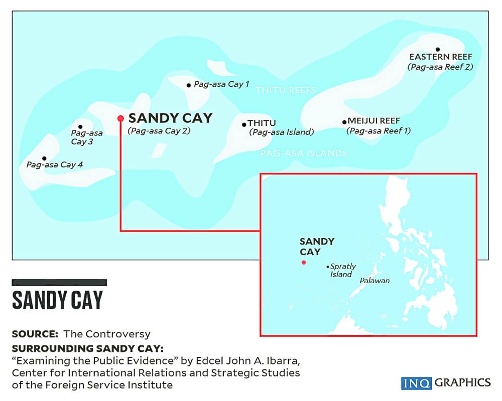
In a forum in Quezon City on Saturday, Jonathan Anticamara of the University of the Philippines (UP) Institute of Biology, said his group had examined the marine life on Sandy Cays 1, 2, 3 and 4 from March 20 to March 23 and found them in a “degraded” state with dead corals piled “higher than a person” on top of live corals.
The research team found coral rubble or dead coral fragments “piled on Pag-asa Cays 1, 2 and 3 that are now exposed during high tide,” Anticamara said in a presentation to the forum.
“The coral rubble are piled on large live coral colonies, suggesting that those rubble are dumped on those live coral colonies,” part of his presentation said.
It added that the pile of sand and rubble on the cays “have many characteristics that are atypical of naturally formed coral or sandy barrier islands, indicating that these are possibly products of island-building activities that are observed in the West Philippine Sea, but with some degree of uncertainty.”
Key indicator
One significant observation was that the slope of the cays was “too vertical,” compared to naturally formed islands whose slopes are gentle due to erosion by the sea.
This is an indication that the dead coral pile was dumped.
“Many of these characteristics suggest that most likely, these piles of rubble were made by humans. It’s not typical of islands in the Philippines,” Anticamara said. “You cannot find an island in the Philippines that it is natural to have the slope as vertical. You can find this in a reclamation area.”
He added that Pag-asa Island itself had “coral reefs that are now experiencing either a decline or degradation, overfishing and the habitat itself is not in good condition.”
“Throughout the Philippines, there’s degradation occurring. But I was surprised that Pag-asa Island itself, which is very far from a lot of fishers and from the mainland, is also suffering from degradation,” he said.
The scientific survey team that visited the cays also included staff from the Department of Agriculture, Bureau of Fisheries and Aquatic Resources (BFAR) and the PCG.
‘Be vigilant’
“The most important thing that we know is that it doesn’t look natural,” Anticamara said.
He said Filipinos must be “vigilant” because China had already built artificial islands close to Pag-asa that had been turned into military bases.
“There is a history of island-building and ongoing island-building in the area, so Filipinos must be very vigilant. We should pay attention and really make sure that we monitor these areas. That’s my main recommendation,” Anticamara said.
Speaking in the same forum, PCG spokesperson for the West Philippine Sea Commodore Jay Tarriela said no other country but China was responsible for the degradation of Pag-asa’s marine life and the dumping of dead corals on the cays.
Harassed, too
“The scientific research conducted by UP and the BFAR was not a walk in the park. They were harassed by the China Coast Guard. They were also harassed by the Chinese maritime militia,” he said.
On the last day of the team’s research, a People’s Liberation Army-Navy helicopter flew about 20 meters above the group, its rotors creating a downwash that scattered dried corals and sand, which caused cuts to some members of the group.
“If there is one country that we need to hold accountable for the damage to our coral reefs in these cays, that will only be the People’s Republic of China, if you were to ask me who is our suspect in doing illegal small island reclamation in the Cays 1, 2, 3, 4,” Tarriela said.
Basis for case
Jay Batongbacal, head of the UP College of Law’s Institute for Maritime Affairs and Law of the Sea, said the government could use the research team’s findings as the basis for a follow-up case to the 2016 arbitral ruling that junked China’s nine-dash-line claim in the South China Sea.
Batongbacal said the act of deliberately destroying coral reefs for reclamation activities is a violation of international law because it contravenes the obligation of nations to preserve and protect marine resources.
“At the very least, this destruction of corals and deliberate alteration of the marine environment can be a basis for another case to follow up the 2016 arbitration ruling,” he said.
The Philippines can also opt for “nonadversarial or nonconfrontational” options by calling on an international organization to conduct a fact-finding mission, Batongbacal added.
No power to waive
Carpio expressed concern over the Duterte-era “special arrangement” on Bajo de Masinloc, even if only temporary.
The Chinese Embassy did not respond to the Inquirer’s request for details on the deal.
“Under the Constitution, then President Duterte had no power to waive, even temporarily, Philippine sovereignty or traditional fishing rights of Filipinos unless the waiver is embodied in a treaty ratified by the Senate,” Carpio said.
He added that the waivers were also considered void as they were accomplished without fully informing Congress and the Filipino people.
“These acts of Duterte caused undue injury to poor Filipino fishermen and to the government through Duterte’s gross inexcusable negligence or bad faith,” Carpio said.
Philippine officials have said that the Chinese were increasingly being aggressive in asserting its claims over the South China Sea, including the WPS, waters within the country’s exclusive economic zone.
A PCG ship and a BFAR vessel were pummeled by potentially “fatal” water cannon blasts from China Coast Guard ships that damaged both on April 30 near Panatag, Tarriela said.
China justified its coast guard’s actions, saying that the Philippine government vessels entered the waters of Panatag without permission in violation of Chinese sovereignty and the 2016 arrangement under the Duterte administration. —with a report from inquirer research