
Share:


An artificial island is slowly taking shape near Sabina Shoal. CONTRIBUTED PHOTO
SECOND OF TWO PARTS
Defense Secretary Gilbert Teodoro called it “pananakop,” Filipino for invasion.
It would be a most appropriate term for the rise of China-built structures in the West Philippine Sea (WPS) inside the Philippine exclusive economic zone (EEZ) and the harassment by the China Coast Guard (CCG) of Philippine Coast Guard (PCG) and Navy vessels.
READ FIRST PART: China’s divide, rule tactic seeks gaps in PH unity to conquer WPS
READ: Teodoro to China: Stop ‘invasion’ through harassment, structure build-up in WPS
Teodoro, who was designated by President Ferdinand Marcos Jr. to lead the Department of National Defense (DND), pointed this out as he called on China to cooperate in easing escalating tension in WPS.
Ambassador Gilbert Asuque, who had been the representative of the Philippines to the International Maritime Organization, told INQUIRER.net that China has obligations under international law, like the United Nations Charter and the UNCLOS.
The UNCLOS, or the UN Convention on the Law of the Sea, is the “constitution for the oceans and the seas,” retired Senior Associate Justice Antonio Carpio pointed out in his book “The South China Sea (SCS) Dispute: Philippine Sovereign Rights and Jurisdiction in the West Philippine Sea.”
Back in 2016, the convention had become the basis of the Permanent Court of Arbitration’s (PCA) decision that China’s nine-dash line, which, Carpio said is the main reason behind the SCS dispute, is without legal basis.
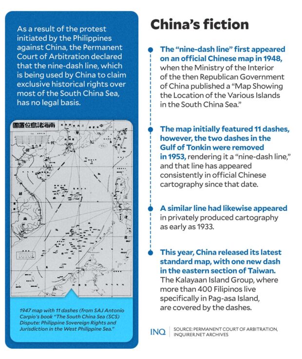
WITHOUT LEGAL BASIS | The nine-dash line, which is being used by China to assert its rights over most of SCS, first appeared on an official Chinese map in 1948. The PCA said the map had no legal basis. (Graphic by ED LUSTAN / INQUIRER.net)
“There is no legal basis for any Chinese historic rights, or sovereign rights and jurisdiction beyond those provided for in the convention in the waters of the SCS encompassed by the ‘nine-dash line’,” the PCA said in a ruling in favor of the Philippines.
Despite this, however, China continued its aggression and, as Teodoro pointed out, did it in plain sight through intimidation of Filipino fishermen and coast guard and unabated construction of artificial islands that are believed to be military in nature.
READ: Teodoro slams China Coast Guard latest harassment of PCG vessel
Last Sept. 11, condemning the latest in a string of harassments by the CCG of PCG vessels engaged in a resupply mission to the BRP Sierra Madre in Ayungin Shoal, Teodoro said the CCG exhibited “irresponsible behavior.”
The government successfully finished the resupply mission but the National Task Force for the WPS said PCG vessels were again confronted by the CCG’s “harassment, dangerous maneuvers, and aggressive conduct.”
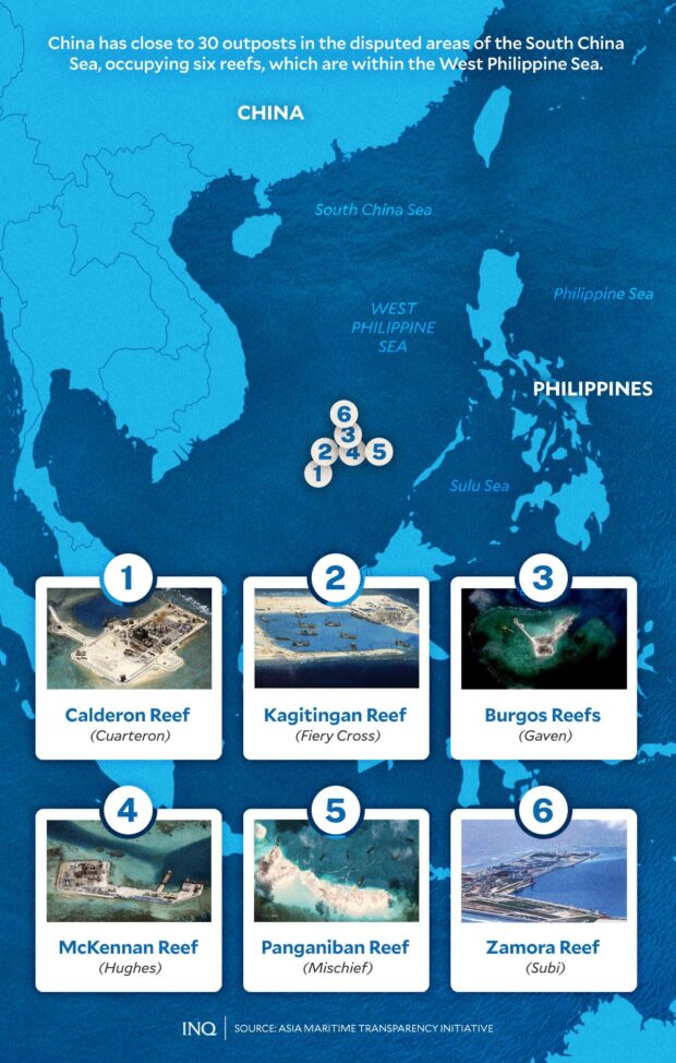
According to data from the Asia Maritime Transparency Initiative (AMTI), China has close to 30 outposts in the disputed areas of the SCS, occupying six reefs, which are within the WPS:
AMTI said China also “controls” Scarborough, or Panatag Shoal, which lies off the coast of Zambales. China seized it in 2012 through constant CCG presence in the area.
AMTI, a watchdog for SCS developments, pointed out that China has been engaged in unprecedented dredging and artificial island building in the Spratlys since 2013, creating 3,200 acres of new land, along with a substantial expansion of its presence in the Paracels.
WITHOUT LEGAL BASIS. The nine-dash line, which is being used by China to assert its rights over most of SCS, first appeared on an official Chinese map in 1948. The PCA said the map had no legal basis. (Graphic by ED LUSTAN/INQUIRER.net)
Both Spratlys and Paracels are considered two of the most prominent geographic features of the SCS. Part of the Spratlys is the Kalayaan Island Group, where more than 400 Filipinos live, specifically on Pag-asa Island.
As stressed by Julio Amador III, president of the Foundation for National Interest and founder of FACTS Asia, “while illegal, China’s artificial island-building strengthens its strategic position in the region.”
READ: Tensions in West Philippine Sea not ‘cooling down’ – Marcos
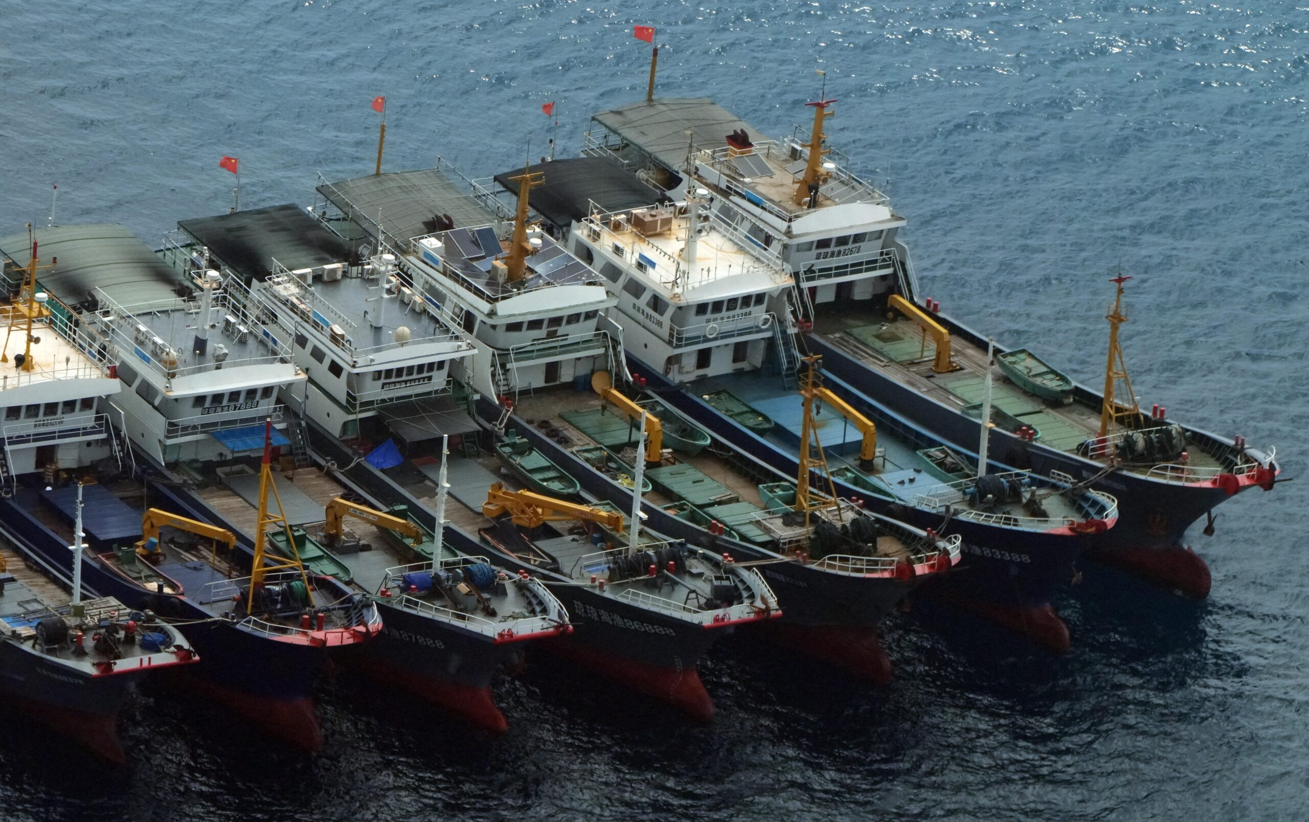
Based on photos provided to INQUIRER.net by a professional civilian photographer, who was on board a private plane, a new artificial island is being apparently developed by China close to Sabina Shoal, which is 135 kilometers west of Palawan.
Taken last month, the photos showed layers of sand with an apparent slope down toward the center. There were militia boats near the man-made island, too, based on photos taken by the same professional civilian photographer in April.
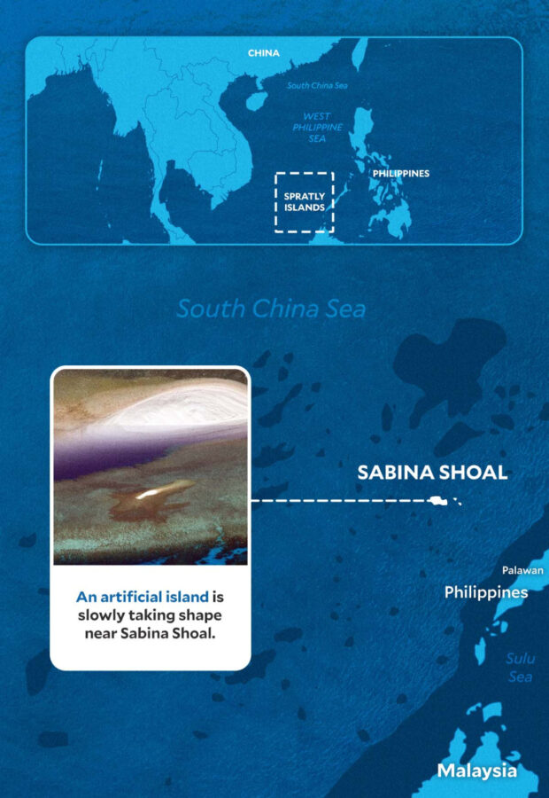
An artificial island is slowly taking shape near Sabina Shoal. (Graphic by ED LUSTAN/INQUIRER.net)
It was pointed out by Amador that despite the PCA decision, “China kept insisting that it had administrative jurisdiction over the SCS, naming the region according to its internal nomenclature.”
He told INQUIRER.net that China is even developing and sustaining activities that seem to mimic “economic activities,” which is a very important justification for claiming features through the UNCLOS.
NON-COMPLIANT. Retired SAJ Antonio Carpio said China’s nine-dash line is bereft of basis under international law. (Graphic by ED LUSTAN/INQUIRER.net)
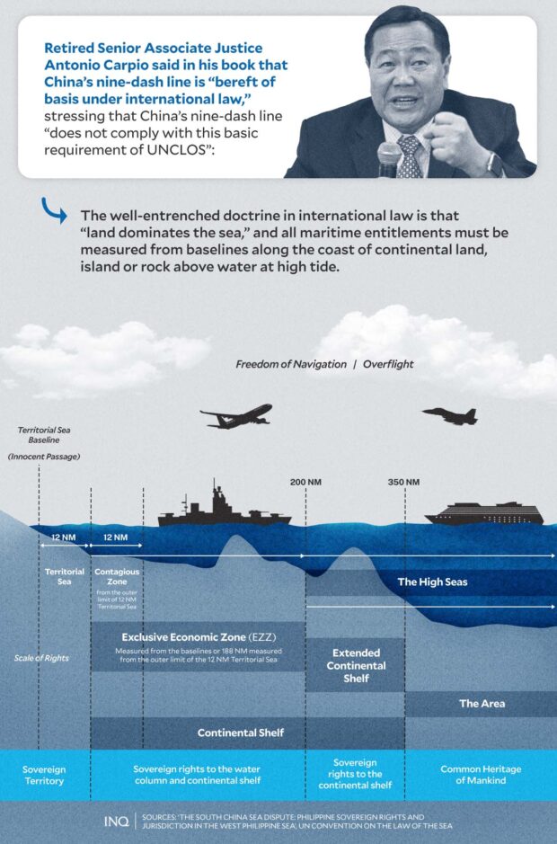
Carpio explained that based on the UNCLOS, “naturally formed” islands capable of human habitation and economic life of their own are entitled to 200 nautical miles (NM) EEZ.
As to artificial islands, however, the convention provided that “artificial islands, installations, and structures do not possess the status of islands,” saying that they have no territorial sea, or the 12 NM from the baselines, of their own.
It is stated in Article 60 (8) of the UNCLOS, which was adopted in 1982, that “their presence does not affect the delimitation of the territorial sea, the EEZ, or the continental shelf.”
CONSTITUTION OF THE SEA. Based on Article 3 of the UNCLOS, continental lands and islands capable of human habitation or economic life of their own are entitled to a 200 NM EEZ. (Graphic by ED LUSTAN / INQUIRER.net)
Rocks above water at high tide but not capable of human habitation or economic life of their own are only entitled to a territorial sea of 12 NM, based on the UNCLOS, which was ratified by all the states involved in the SCS dispute:
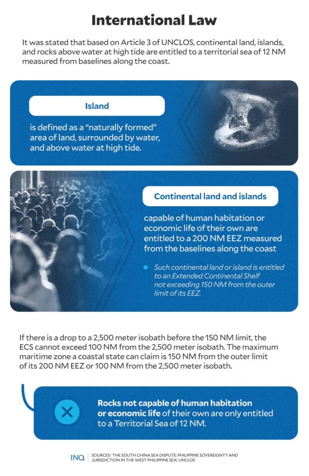
Close-up shot of some of the so-called “tanmen” boats standing guard near the artificial structure. CONTRIBUTED PGHOTO
China’s man-made islands, Amador said, are “illegal before international law.”
As the PCA decided and explained by Carpio, out of the seven reefs occupied by China in the Spratlys, five, including four within WPS, are high-tide elevations and are entitled to 12 NM territorial sea.
The other two reefs — Mischief or Panganiban Reef and Subi or Zamora Reef — are low-tide elevations. Mischief Reef is part of the continental shelf of the Philippines and only the Philippines can legally erect structures or artificial islands on the reef.
It was decided, too, that Subi Reef is within the territorial sea of Pagasa Island which is occupied by the Philippines. “Thus, Subi Reef is subject to the sovereignty of the Philippines and only the Philippines can erect an artificial island on Subi Reef,” said Carpio in his book.
So why is China constructing artificial islands?
Don McLain Gill said: “Artificial islands are a way for China to not only secure its presence in the disputed maritime territory but also project power and establish more ardent A2/AD capabilities against Southeast Asian and extra-regional states.”
A2/AD, or anti-access/area denial, is a strategy to control access to and within an operating scene.
“These also serve as a sort of permanent offshore base to more effectively check US military capabilities in the region. China is thus able to leverage its geography in this way,” Gill, a geopolitical analyst, told INQUIRER.net.
He stressed that evidently, such assertion will also affect the Philippines, not only on the security of its sovereignty and sovereign rights but also its economic interests in the greater SCS.
As Carpio pointed out, because of China’s assertion of its nine-dash line, 80 percent of the exclusive economic zone of the Philippines is at stake, comprising 381,000 square kilometers of maritime space.
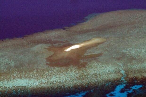
Photo shows the expanse of the man-made island in the West Philippine Sea. CONTRIBUTED PHOTO
Amador said if China will successfully reign in the SCS through artificial island-building, logistical deployment of air and naval assets, moving personnel, armaments, and cargo will exponentially be easier for China.
“Chinese air and naval assets will be able to interdict foreign-flagged vessels with relative ease,” he said. Likewise, there will be an ‘exponential’ increase of presence of naval and air assets of China, on top of its maritime militia,” Amador said.
He said because the gray zone is China’s prevailing military doctrine in the SCS, increased encounters at sea and air will also increase risks of miscalculation.
“Sustaining operations in the artificially-built islands can also mean that China may develop air and naval assets in-island, lessening risk of vessel weariness/fatigue and increasing cycle of operations that littoral states will not be able to keep up with,” said Amador.
Amador pointed out, too, that with the fishing moratorium that China is imposing on seas where its fishermen operate, “this moratorium could de facto expand to include the entirety of the SCS covered within the 10-dash line claim,” referring to a new China map showing its claims expanding.
He said: “In a geopolitical perspective, the offshore archipelago of China is aligned with their recent publication of the new version of their 10-dash line map.”
“China’s strategy of calibrating proportion of intimidation and coercion shows a definitive aggression of China’s claim of historic right over the South China Sea,” he said.
On the presence of militia vessels, Amador said there is no definitive way to confirm whether their presence is associated with artificial island-building. “What can be gleaned from, however, are historical precedents that detail exactly similar series of events,” Amador said.
Based on Carpio’s book, it was in 1987 when China occupied Fiery Cross Reef, a two-square meter high-tide elevation protruding less than a meter above water at high tide.
China occupied Fiery Cross Reef on the pretext of building a weather radar station to assist UNESCO in its global oceanic survey, Carpio said, but from 2014 to 2015 it dredged and reclaimed Fiery Cross Reef into a 270-hectare island, hosting a military airbase with a 3-kilometer military-grade runway and a seaport.
Then in 1988, China seized Subi Reef from the Philippines. China later created a 394-hectare artificial island on Subi Reef hosting a 3-kilometer military-grade runway and a seaport.
It was in 1995 when China seized Mischief Reef from the Philippines. China at that time explained that the stilt structures it built on Mischief Reef were mere shelters for Chinese fishermen.
But Carpio pointed out that from 2014 to 2015, China dredged Mischief Reef and created a 590-hectare artificial island, hosting an air-and-naval base with a 3-kilometer military-grade runway.
Then in 2012, China seized Scarborough Shoal from the Philippines. From April to June 2012, there was a standoff between Philippine and Chinese vessels around Scarborough Shoal.
As Amador pointed out, “China is using large Chinese Maritime Militias to assert and expand its control over an increasingly large area of maritime areas and reefs not just in the West Philippine Sea rather in a whole area of South China Sea.”
Amador said China is not actively threatening invasion, but its actions seem to point towards that.
“The overarching rationale of the gray zone principle is to unjustly compel the aggrieved party to make the first wrong move or decision that will preempt and justify a commensurate military response, thereby unnecessarily giving countries like China the false impetus to retaliate with an even sizable response,” he said.
According to Amador, the Philippines must play a higher game. Its remarkable triumph in the 2016 arbitral award accorded the Philippines a moral and legal victory — a different ballgame that China will never win even if it refused to recognize the proceedings or the ruling.
The more China speaks of this line of thinking, the more it will destroy its own credibility, Amador said, stressing that “China’s aggressions are a clear indication of its intimidation to claimant states in the South China Sea region.”
There is a need to “emphasize the importance of the UNCLOS and have allies rally behind us,” Amador said. “As per UNCLOS, only the Philippines has the right to construct artificial islands in our EEZs,” he added.
READ: Bongbong Marcos, US VP Harris discuss South China Sea
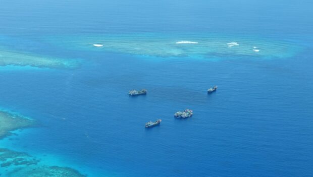
Chinese militia boats stand guard near the man-made island in Sabina Shoal. CONTRIBUTED PHOTO
It was stressed by the Advocates for National Interest that the continuous presence and stationing of China Coast Guard and maritime militia vessels in areas around Ayungin Shoal and within the Philippines’ EEZ “violate the concept behind the freedom of navigation which only allows entry and exit but not to remain stationary.”
Resisting this, however, will not be easy.
Amador said it is important to acknowledge that the Philippines’ options are very limited without overtly provoking China, short of a declaration of war.
“Documenting the PRC’s aggressive behavior and filing diplomatic protests are critical parts of the country’s toolkit in responding to aggressive behavior,” he said.
The Philippines has thus far protested observable and contestable encroachment, but no outright protests have been made on China’s offshore artificial island-building. The Philippine government needs to verbalize its displeasure in the strongest of terms against China’s illegal artificial island-building.
He pointed out that the PCG will not be able to do all the work. “It is time to test the Philippine Navy’s conviction in preventing the delivery of building materials that will augment China’s artificial islands,” Amador said.
Interdiction operations will have to be done within the limits and bounds of international law, saying that even if CCG manages to outmaneuver PH assets, playing by the rules while showing PH resolve sends a strong signal to China.
It’s already time, too, he said, for the Philippines to set its archipelagic house in order: “Pass the Maritime Zones Bill and the Archipelagic Sea Lanes Bill,” said Amador.
“These laws will bring front and center the Philippines’ vision for its maritime domain and the truest acknowledgment that the country’s identity cannot be separated from its maritime and archipelagic characteristics,” he said.
READ: PH, Australia planning joint patrols in South China Sea
READ: PH gov’t told to ‘popularize’ 2016 PCA ruling on South China Sea than targeting ‘Barbie’
“These laws will also give impetus to maritime law enforcement agencies, empowering them and giving them the legal mandate to protect these areas beyond reasonable doubt,” Amador said.