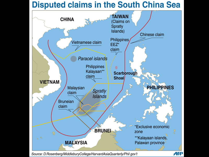
Map showing the disputed areas in the West Philippine Sea, including the Spratly Islands and Scarborough Shoal. AFP FILE
MANILA, Philippines — Senators on Thursday rejected China’s new version of a map which it called the “10-dash line” that includes the eastern section of democratically-ruled Taiwan and most of the West Philippine Sea.
In a statement, Deputy Minority Leader and Senator Risa Hontiveros dismissed China’s effort as a “desperate attempt” to push its schemes.
“China is delusional,” she said. “This ‘map’ is Beijing’s desperate attempt to assert its lies and propaganda.”
Hontiveros urged the Department of Foreign Affairs (DFA) to coordinate with the National Resource and Mapping Authority to update a map that clearly shows the Philippines’ Exclusive Economic Zone (EEZ), continental shelves, and territorial seas in the West Philippine Sea.
READ: China’s new ’10-dash line’ map incorporates Taiwan, most of West PH Sea
She further urged the DFA to lodge a diplomatic protest against China.
“We know that China is a master manipulator, willing to bend the truth for her own gain, at the expense of countries like ours,” Hontiveros said. “China will continue to spread fake news, fund pro-Beijing mouthpieces, and distribute propaganda materials. We must push back. We must not rest until China stops her absurdity.”
Senators Francis “Chiz” Escudero and Aquilino “Koko” Pimentel likewise ignored China’s latest action.
“They can issue however many maps they want to issue. It does not affect us nor does it impinge on the Arbitral Ruling in our favor,” Escudero said in a message to reporters. “Any unilateral declaration by a State has no weight nor standing in international law.”
READ: China should ‘act responsibly’: DFA junks Beijing’s ‘10-dash line’ map
“We should stop being affected by China’s issuances or statements. Let us not allow China to dictate the tempo by simply being reactionary. We should do what we think is right and in accordance with our national interest,” he added.
Pimentel, meanwhile, asserted that the Philippines is not “under any obligation to recognize the territorial claims of other countries.”
“It is important to concentrate on our own position: on the extent of our territorial claims as well as maritime zones,” he said in another message to reporters.
READ: Key points of the arbitral tribunal’s verdict on Philippines vs China case
Beijing’s Ministry of Natural Resources released its new “10-dash line” map – which used to be “nine-dash line” – on August 28, according to the state-run website China Daily.
The new map places an additional dash at the eastern section of Taiwan, which Beijing insists is a renegade province subject to reunification with China, and puts the entire Spratly Islands, which include the Kalayaan Island Group that is within the Philippines’ EEZ, inside Beijing’s self-conceived border.
China’s nine-dash line claim was invalidated in July 2016 by the historic ruling of the United Nations-backed Permanent Court of Arbitration, which favored the Philippines’ stance on issues surrounding the disputed South China Sea, including the West Philippine Sea.
READ: PH wins arbitration case over South China Sea


