


China’s mischief: Expansion, reclamation
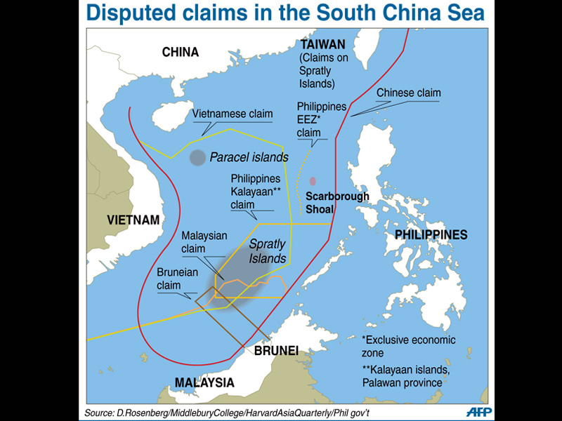
Map showing the disputed areas in the West Philippine Sea (south China Sea), including the Spratlys Islands and Scarborough Shoal. AFP
PUERTO PRINCESA CITY, Philippines—China has deployed a dredging ship at the disputed Panganiban Reef (Mischief Reef) and is doing “substantial” reclamation in the partially submerged area, signaling Beijing may be preparing to expand its facilities there, according to the military command that is directly in charge of securing the country’s maritime interests in the West Philippine Sea.
China has been earnestly conducting dredging activities at Panganiban Reef—a Philippine-claimed area in the Spratly group of islands, which Beijing occupied in the mid-1990s —similar to earlier reported land reclamation work in other areas of the Spratlys, said Rear Admiral Alexander Lopez, chief of the Western Command (Wescom) of the Armed Forces of the Philippines.
“We don’t know what they plan to do in Mischief. It is already a garrison to begin with and far from being just a fisherman’s shelter, which was what (China) claimed when they first occupied it,” Lopez said.
Aerial photos
Lopez did not say when China started the dredging work or give any details on the extent of reclamation at Panganiban Reef, saying only the work had been “substantial.”
He said the Navy has taken aerial photographs of the reclamation activities at Panganiban Reef but that his command was not authorized to release those photos.
But Lopez said the physical change in Panganiban Reef since the dredging “has been substantial.”
He said Panganiban Reef has been functioning as a base for Chinese frigates that have been patrolling the area.
Note verbale
Panganiban Reef, one of the rocky islets in the Spratlys archipelago that is being claimed by the Philippines as it lies just 135 kilometers southeast of Palawan and within the country’s exclusive economic zone (EEZ) and its continental shelf, was taken over by the Chinese in 1995 over the protests of the Philippines even as Beijing claimed that they only intended to build shelters for Chinese fishermen that visit the area.
The Department of Foreign Affairs (DFA) on Friday said it has already lodged a protest with China concerning the land reclamation activities at Panganiban. It said the protest was included in the note verbale that it handed last Wednesday to Chinese Embassy representatives which also expressed the Philippines’ strong objection to the stepped-up Chinese building activities at Kagitingan Reef (Fiery Cross Reef), also part of the Spratlys, accusing China of planning to build an airstrip on top of land dredged from around the area, in violation of previous international agreements.
“China’s reclamation activities constitute a flagrant violation of [the Philippines’ exclusive right to authorize construction of artificial islands, installations or other structures in the vicinity of Panganiban Reef under the United Nations Convention on the Law of the Sea] and increase tensions in the region,” the DFA said.
China has claims on almost the entire South China Sea, which is believed to have rich deposits of oil and gas. Brunei, Malaysia, the Philippines, Vietnam and Taiwan all have sovereignty claims on the sea and its mostly uninhabited islands that is a marginal part of the Pacific Ocean where about $5 trillion of ship-borne trade pass every year.
6 other reefs
Last year, Chinese President Xi Jinping tried to set Southeast Asian minds at ease over the country’s regional ambitions, but Beijing’s reclamation work in the Spratlys underscores its drive to push claims in the South China Sea and reassert its rights.
China has already undertaken reclamation work on six other reefs it occupies in the Spratlys, expanding land mass five-fold, aerial surveillance photos show. Images seen by Reuters last year appeared to show an airstrip and sea ports.
Surveillance
IHS Jane’s said in November images it had obtained showed the Chinese-built island on the Kagitingan Reef to be at least 3,000-meters long and 200- to 300-meters wide.
Surveillance photos that were taken of Panganiban Reef last October showed no reclamation work in the area.
The photos, seen by Reuters, showed two structures, including a three-story building sitting on an atoll, equipped with wind turbines and solar panels.
In 2002, Southeast Asian states agreed with China to sign an informal code of conduct in the South China Sea to stop claimant states from occupying and constructing garrisons in the disputed Spratlys.
Last year, the Philippines and Vietnam protested China’s reclamation work as a violation of the informal code.
PH fishing boats rammed
Just last Thursday, the Philippines accused China of ramming Filipino fishing boats off the disputed (Panatag Shoal) Scarborough Shoal, north of Panganiban Reef, and demanded that Beijing respect its sovereignty over the potential flash-point territory.
The DFA said it had sent two notes of protest over the Jan. 29 incident off Panatag Shoal, as well as the removal of critically endangered giant clams by Chinese fishermen in the area a week earlier.
China’s foreign ministry immediately fired off a stern rebuke and defended the actions of its coast guard vessel, claiming that the Filipino fishing vessels were “illegally lingering” in the waters surrounding Panatag Shoal, prompting its coast guard to send a dinghy “to drive them away and slightly bumped one of the fishing vessels.”
A Philippine military spokesperson, Col. Restituto Padilla, described China’s action as “alarming” saying the local fishermen were trying to seek shelter due to bad weather.
Creeping invasion
China has controlled Panatag Shoal, a rich fishing ground in the South China Sea (referred to as the West Philippine Sea by the Philippines) 220 kilometers west of Luzon, since 2012 following a tense standoff between the Philippine Navy and Chinese maritime patrol vessels.
The Philippines has alleged that China’s actions in the South China Sea were part of a creeping invasion and has asked a United Nations arbitration panel to rule on its maritime disputes with Beijing which has refused to participate in the proceedings.
China occupied Panganiban Reef in 1995, building makeshift huts, which Beijing claimed provided shelter for fishermen during the monsoon season. But it later built a garrison in the area, deploying frigates and coast guard ships.
“China intends to seize as much of the South China Sea as possible,” said Michael Tkacik, a security specialist with the Texas-based Stephen F. Austin State University, in a security forum in Manila on Wednesday.
Sparring over islands, shoals and outcrops might drag China into conflict with another superpower, the United States, a longtime military ally of the Philippines, he warned. With reports from AFP and Christine Avendaño
RELATED STORIES
DFA tells China: Stop harassing Filipino fishermen
Chinese ships ram PH fishing boats


