


China builds radars in disputed sea
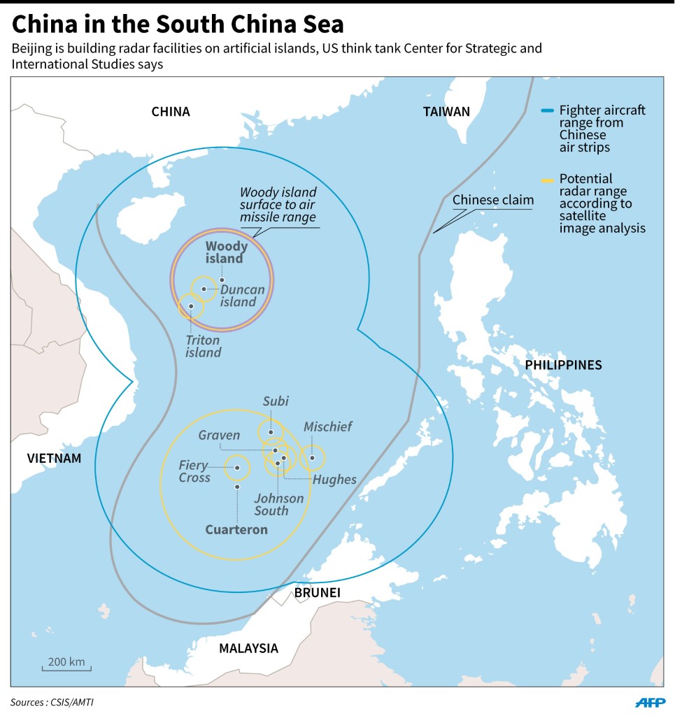
Map showing potential Chinese radar cover in the South China Sea, according to analysis by US-based Center for Strategic and International Studies. ADRIAN LEUNG / AFP
BEIJING—The Chinese government is installing radar facilities on artificial islands in the disputed South China Sea in a move that could “significantly change” the operational landscape, a US think tank reported on Monday.
Recent satellite images of Philippine-claimed Calderon Reef (international name: Cuarteron Reef) in the Spratly Islands released by the Washington-based Center for Strategic and International Studies (CSIS) show what appears to be a high-frequency radar installation as well as a lighthouse, underground bunker, helipad and other communications equipment.
The Asian Maritime Transparency Initiative of CSIS said the images showed that construction of the radar facilities on Calderon Reef appeared nearly complete and that the artificial island now covered an area of about 210,500 square meters (52 acres).
“Two probable radar towers have been built on the northern portion of the feature, and a number of 20-meter (65-foot) poles have been erected across a large section of the southern portion,” the report said.
High frequency
“Placement of a high-frequency radar on the reef would significantly bolster China’s ability to monitor surface and air traffic coming north from the Malacca Straits and other strategically important channels,” it added.
China’s foreign and defense ministries did not immediately respond to requests for comment from international news agencies.
Calderon Reef is controlled by China but is claimed by the Philippines as part of the Kalayaan group of islands in Palawan province.
The latest photographs come only a week after US officials said China had deployed surface-to-air missiles in the Paracel Islands further north, heightening tensions in the strategically vital region.
The CSIS report said satellite images showed that China appeared to also have constructed a quay with a loading crane on the reef.
Based on analysis of satellite images from January to February, the report said China already had significant radar coverage of the northern part of the South China Sea given its mainland installations and on the Paracel Islands to the northwest of the Spratlys.
Both the United States and Vietnam last week expressed concern at China’s deployment of advanced surface-to-air missiles on the Paracels.
‘Landscape changed’
CSIS described as “notable” China’s earlier deployment of HQ-9 surface-to-air missiles, but the US think tank added that “does not alter the military balance in the South China Sea.”
“New radar facilities being developed in the Spratlys, on the other hand, could significantly change the operational landscape,” CSIS said.
In recent months, the US Navy has sent warships to sail within 22.2 kilometers (12 nautical miles)—the usual territorial limit around natural land of a disputed island—of one of Beijing’s artificial reefs in what Washington says is a defense of the right to free passage.
China claims most of the South China Sea, through which more than $5 trillion in global trade passes every year. The Philippines, Vietnam, Malaysia, Brunei and Taiwan have rival claims.
A high-frequency radar on Calderon Reef would increase China’s ability to monitor sea and air traffic coming north from the Malacca Straits and other important channels, according to the CSIS report.
CSIS also pointed to “probable” radars as well as helipads and gun emplacements built by China on Philippine-claimed Burgos (Gaven), Subi (Hughes) and Mabini (Johnson South) Reefs in the Spratlys.
Beijing previously operated radars on Philippine-claimed Kagitingan (Fiery Cross) Reef, but the latest radar installations would give the Chinese military far more extensive coverage, according to regional analysts.
Wang visit
The CSIS report comes on the eve of a US visit by Chinese Foreign Minister Wang Yi, during which US concerns about China’s assertive territorial claims will be high on the agenda.
Mark Toner, a spokesperson for the US Department of State, said the United States would “press China to deescalate and stop its militarization” in the South China Sea.
Toner said China’s “militarization activity” only escalated tensions. “There needs to be a diplomatic mechanism in place that allows these territorial claims to be settled in a peaceful way,” he added.
Wang is due to meet US Secretary of State John Kerry on Tuesday. Their talks will also include the international response to North Korea’s recent nuclear test and rocket launch, cybersecurity and climate change, Toner told a regular news briefing.
In a talk with reporters last week, Kerry said, “There is every evidence, every day, that there has been an increase of militarization of one kind or another. It’s of a serious concern.”
US President Barack Obama last week called for “tangible steps” to lower tensions in the region.
The Obama administration is under congressional pressure to step up the US response to China’s activities in the South China Sea. Lawmakers are expected to raise their concerns on Tuesday in the Senate armed services committee which has summoned the commander of US forces in the Pacific. Reports from the wires


